
Macroscopic Description:
Mud Volcanoes in Trinidad are formed when gases interact with sediments as they escape along fault lines. Once no reaction occurs only a gas seep would be formed (Märky 1931).
Some can be found within the highly active Naparima Nariva Fold Thrust Belt, with the remainder associated with the Siparia-Ortoire Syncline and the Southern Anticline (G.E. Higgins, J.B. Saunders. 1974).
The Naparima Nariva Fold Thrust Belt is located south of the Central Range Uplift and north of the Southern Range Anticline. The area is a strongly folded succession of Lower Tertiary, late Oligocene-middle Miocene muds and sandstones and is deemed to be a source of many mud diapirs with a thickness of 5000m (G.E. Higgins, J.B. Saunders. 1974). It comprises of dark calcareous silts and sandy beds and its overlapping is responsible for the separation of the Central Range to the north from the Southern Basin (J. Pindell, L. Kennan 2001) . This Belt overlies the Lower Cipero Fm. and on maps is shown as stringers within the Nariva Fm. (J. Pindell, L. Kennan 2001).
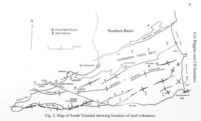
Location of the Naparima Nariva Fold Belt Modified after (G.E. Higgins, J.B. Saunders. 1974)
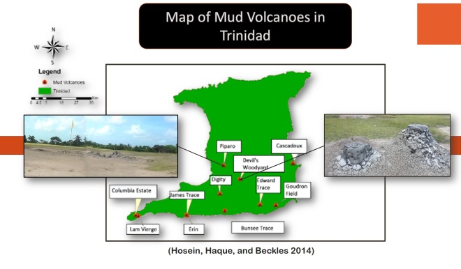
Existing sites shown on the Featured Map include:
- Piparo
- Devil’s Woodyard
- Cascadoux
- Edward Trace
- Goudron Field
- L’Eau Michel, Bunsee Trace
- Digity
- Erin
- James Trace
- Colombia Estate, Fullarton, Cedros.
- Lam Vierge
- Point Radix (The Offshore Volcano)
Other Mud Volcanoes in Trinidad include:
- La Bouffe
- Gafla, Cedros
- Anglais Point
- Palo Seco
- Chagonaray
- Coora
- Morne Diablo
- Karamat
- Moruga Bouffle
- Lagon Bouffe
- Tabaquite
- Chatham
- Point Radix (Offshore Mud Volcano)
